James Bay Descent
Posted by Steve on 06/21/19
Last modified: 02/01/21
Words by Buck Miller
Photos by Eric Batty
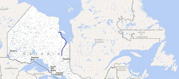
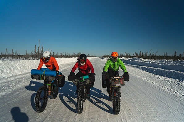
In February of this year, myself and three friends headed to the far North of Ontario, Canada, for a 397 mile fat bike expedition. This region is well known for its dry, bitter cold, funneling down from the Arctic to the massive gash that Hudson and James Bay make in the center of our country. While it’s easy to see on a map as the area where the Arctic Ocean drops very far south, it’s hardly known as a place of exploration in today’s modern world. Our route went through some areas of first contact between the Europeans and the Swampy Cree Indigenous peoples, some 430 years ago. It is tough, unforgiving country in the land of polar bears, seals and beluga whales.
Ted King. A well-known name in road, gravel and Pro Tour racing, the word ‘retirement’ after 10 years as a professional hardly describes his post-pro life. He still raises his arms in the air a few times a year in most of America’s biggest gravel races. He’s written for many media outlets including VeloNews and Bicycling. Ted co-founded UnTapped; a sports nutrition company based on pure Vermont maple syrup. The King of the Ride podcast and the Rooted Vermont gravel race are his latest projects. Ted spent the most time on the front during the James Bay Descent and no one waited for him during his pee breaks.
Eric Batty. Does that last name ring a bell? Eric is a former pro mountain biker who has a few top 30 World Cup finishes in his palmarès. While he was racing, there was always another sport pulling some time from his training schedule. He once rode 100 miles outfitted with a backpack just so he could bring sneakers to run up a mountain in Arizona. You can find him rock and ice climbing, riding, running, working on the family farm, cutting trees as an arborist or traveling to the mountains to take beautiful pictures. He is the eldest brother of the Canadian Olympic Cyclist, Emily Batty. Due to camera/film gear, Eric had the heaviest bike and sweat the most on the James Bay Descent
Ryan Atkins. Who’s the fittest person you know, or have heard of? Now, forget about that person and replace their name with Ryan Atkins. As a pro Obstacle Course Racer, the most all-around athlete on earth could likely be this cat. He trains full time across a multitude of different sports in order to dominate the last 5 years of OCR racing around the globe. He’s as comfortable in the mountains with ice tools and skis as he is running for 8 hours in the heat of summer. Before he went full time OCR, he was a 2x world champion in unicycle trials. No kidding. Google it. One could say he’s well balanced athlete. Ryan easily ate the most food and cracked the most jokes on the James Bay Descent.
Buck Miller. Chief engineer of this project, me. I lived on the James Bay coast for 5 years, where I started my family and a career in carpentry. My daughter, Eleanor, was born in Moose Factory, the halfway point of the route. My ramblings around this land started in my youth. By canoe, boat, foot and skidoo, I have explored these rivers, creeks and swamps in all seasons. A family move to southern Ontario as a kid is how I started bike racing. I raced pro on the road for 7 of my 10 years of training full time. Buck (I) was the slowest rider on the James Bay Descent.
The long drive North
We all met at my house in Huntsville on February 3rd. After a night of packing and repacking, Ted, Ryan and I are all set, we think. Eric gets to my place at 11:30pm but insists his packing game is tight. It was. We roll out in the morning at 5am. With no bike shops between home and our starting town of Attawapiskat, now isn’t the time to forget anything.
The drive north takes 15 hours, 9 of which are on a seasonal road. We get to drive our entire route in reverse this way: Smooth Rock Falls to Attawapiskat First Nation. Eric’s work truck takes a beating. On this road, there’s hardly any maintenance other than snow clearing. No watering to fill in the holes, no grading to cut off the high spots. Two of us in the back seat would rather be dead right about now and we’re still 3 hours away. We stop to stretch and lock the wheels in to 4x4 for the last bit of the drive. Finally, we’re there. Moosonee tonight, 3 hours to Attawapiskat tomorrow morning, then we roll out.
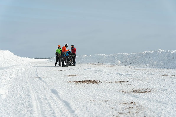
The entire ride was a first of its kind. We would be the first to ride the entirety of the James Bay Winter Road self-supported. Only 3 riders previously attempted this. One quit and was picked up by the police with severe frostbite on his toes, the other two rode half of the route, 300k, but stayed half way in a B&B, riding only with their daily food and clothing needs on their bikes. While that’s still hard, we wanted to go next level and decided to ride on James Bay, the land of salt water, seals, beluga whales and polar bears. We attempted to get to Akimiski Island, a part of the arctic territory of Nunavut, then head 370 miles south to finish the ride. Uneventfully, we only crossed the geographical border into Nunavut, and couldn’t step foot on the island because of a long, thin band of open water and a detour around it that would have cost us 3 days, all of which would have been in polar bear country. With only a .12ga for bear defense, sleeping would have been restless, so we decided against the crossing, that and out there, -40F and water coexist in a dangerous discordance we don’t want to meet.
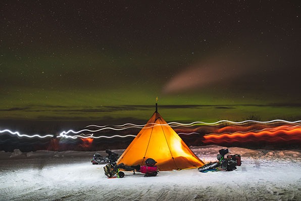
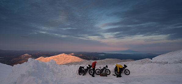
Leaving the truck, we rolled out a short 7 miles, under a sunny -30F, to our first camp at the edge of James Bay. Local Muskego Cree people were happy to say hello, snap pictures, and warn us of the cold snap they’ve been in for a few weeks now. We assured them our Timmermade Thrush Sleeping Bags were good to -40F. Some still didn’t think we were prepared even after seeing our set up, including the wood stove. The night would test our gear hard, though, and came in a hair colder than -40F and lit the sky with the Auroras. Other than the draft under the tent from sleeping on hard ice and not having snow near to throw around the base of the tent, we stayed warm, but made sure to not let it happen again. Up in the morning, we broke camp and headed to the bay for a few hours of wildly exposed snow and ice. We could see vapor on the horizon and realized it was the open water hitting the cold air. The decision to flip it and start our way south was made and by the day’s end we knocked off a little over 30 miles and tucked the tent tight to the bush on a riverbank. Up here, if you’re not beside a creek or river, the trees are very sparse and short. Not ideal for keeping out of the wind. That night, the Mushkegowuk Grand Chief stopped by our tent to wish us safe travels through his traditional lands and gave us a weather report.
 You’ll find the team in
 I really dig the 3rd and 4th days of trips like this. By now, I’ve settled into the gear choices I’ve made, have a few miles in the legs, and the routine is getting dialed. We heard of a storm headed our way from folks traveling on the ice road. Many stop to take pictures, say hello and ask how we’re doing, or simply to say that they’ve heard about our trip, and that they were hoping to run into us on the ride. They’re reporting 4 to 20 inches, everyone with a different number. I tell the lads, “hey, it’s bloody cold, in the -30’s, we never get snow up here this time of year, it’s more like a desert, we’ll be fine.” Regardless, we push hard on day 3 to knock out 60 miles because any snow at all will slow us down. Road conditions were defined by lumpy, bumpy, hard yellow ice, so with the 45NRTH Dillinger 5 tires down to 3 psi or less, we were staying upright and making good time. We camped in a swamp where a moose had been killed earlier that day. We saw it being towed behind a truck on the ice road 6 hours earlier. Spatterings of blood and bits of hair were dead giveaways. Up here, if you have 4 legs and your back faces the sky, you will end up in a freezer if you cross paths with an expert Cree hunter. Hunting is what these people do, they’re masters of the trade. Groceries are priced out of this world as transport trucks can’t haul on these 8 week routes so all food gets flown in. The morning of day 4, we tore down camp really quickly and hit the road. Dark sky overhead and a light snow followed us all day. We ran into a flock of sharp tailed grouse before noon. I took the gun off the bike, got the snowshoes and was pumped to add some protein to our dehydrated dinners. Gun loaded, I didn’t get my foot in the snowbank before a dozen of them lifted up and flew off. Not even close. Good thing we like the forever young mac’n’cheese. We knocked out 74 miles, riding the wave of a tailwind and set up camp 2 miles from our halfway point, Moosonee, my old stomping grounds. That night, a blizzard dumped 10” of fresh pow and 45 mph winds that lasted over 18 hours caused huge drifts. We spent the next day, day 5, touring Moosonee with a stop at the public school for a chat with the kids.
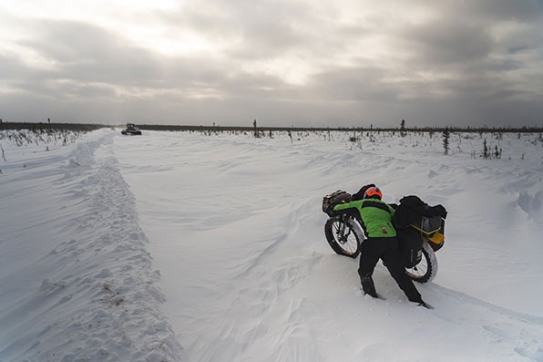
We’re officially halfway done and have settled into our roles. Ted and Ryan are tent pros, setting up the tipi without haste. Eric is behind the lens and getting firewood. I’m building an open fire just to warm the team as we all work to set up camp. We’re an hour before we get the wood stove in the tent and hot enough to provide respite. The outdoor fire is a winner, but it’s hard to leave and I’m starting to feel like I spend more time with it than the rest of the team. Their humor confirms my thoughts. Days on the bike from now to the end of this 110 mile ice road section are brutal and the wind is nailing us head on. We’re constantly being slowed by heavy equipment. Because of the blizzard, the road has disappeared. There’s no markers, no guardrails. Just a swath cut through the wispy, stunted trees and cranberry swamps. Any progress was futile. We’d be waiting on the side of the road, in a treeless barren ground where the drifts wrought most havoc. Ride six miles, stop for an hour. Ride another six miles, stop for an hour. We’ve all packed so light that when we’re stopped, it’s not like we have basecamp clothes for comfort. Our comfort when stopped comes from the tent and wood stove. We’re happy to see this day end after 31 miles and we set up camp at South Bluff Creek, a place I know very well in the summer months. The wind is still ripping, so we set up a snow wall by cutting and breaking hard snow from the bank and place it around our bikes on the upwind side to get some protection. We sleep well.
A bluebird sky to greet us and another day of headwind and -30F. With the road closed to traffic, it’s just us and the equipment riding around out here. 2 graders, 1 loader, 1 bulldozer and a huge tractor. Today we’re able to move slowly, but steady. The ground beneath the cutting blades is anything but flat. It’s constantly changing. Stumps, mudholes, clumps of grass, holes and even the odd beaver house. So when the plow goes by it’s still soft, terrible snow. A far cry from our first leg of the trip which you could skate on. Today, I spend about 40 of the 50 miles we ride on Ted’s wheel, comfortably lapping up the draft off the 6’3” workhorse. We camp on Big Cedar Creek, a place where an extended family member of mine had a trapline in the 1930’s. This evening, a family from Fort Albany decided to take their chances on the winter road although it wasn’t open to traffic yet. An elder rolled down the window and waved me over. Insisting I take my glove off, he places dry tobacco in my hand and closes my fingers, holding my hand in his. He says a prayer in Cree, to his Creator, and instructs me to sprinkle it over the fire. A prayer for safe passage, he says. Gichi Miigwetch.
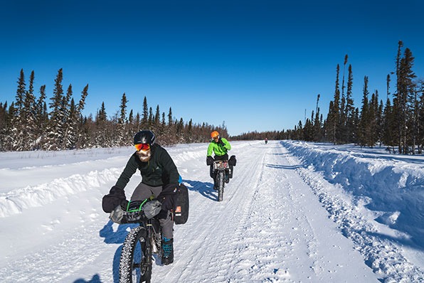
The next morning was bloody cold. Another -40F, so pushing away from camp was hard on the hands to start. I used 45NRTH Cobrafist pogies and Nøkken gloves that were a great combo. We hammered from the gun. No warm up, just on the bike full gas for 20 minutes. Our stops for food were only a minute or two each. Our ice beards were grand and every bit of skin was covered up. All agreed that today was the hardest but with Smooth Rock Falls only a few days away, we were able to ride a bit harder and not worry as much about sweating. The kilometers ticked by, we didn’t talk too much and just focused on the wheels in front other than cracking a few jokes about things that rhyme with Ted. Ted Zeppelin and Right Said Ted were some favorites. Not to mention the terrible Ted wind we’d been fighting for days, and so on. The end of the ice road business is only 25 miles away and then we’re on to big rollers and a gravel road. That was some pretty good motivation. We rolled well and in 3 hours we were there. The sun was out, our spirits were high, and the morning cold snap wasn’t noticed. Feeling the first few turns of the pedals on the gravel reminded me of my years racing bikes full time. It was like I had a winter of base miles in the legs, and the riding was just so easy. Ryan threw down and Ted jumped on the wheel. Ryan is always training, so Eric and I chilled, and took in the sights of passing log trucks and enjoyed the ride. We rode over Eleanor Creek; the place my family took drinking water from on our way to the family trap camp. I remember it so fondly that I named my daughter after this place. Our day ended after 60 miles on the bike and only 50 left to ride. We got word over our Garmin InReach that we’ve raised about $7000 for the Moosonee Native Friendship Centre at our GoFundMe page. This whole ride was fun and we had some selfish reasons to ride it, but ultimately, we wanted to give back to those who live in this region. History between our government and Indigenous people is pretty terrible. Giving back, even in a tiny way, was the least we could do.
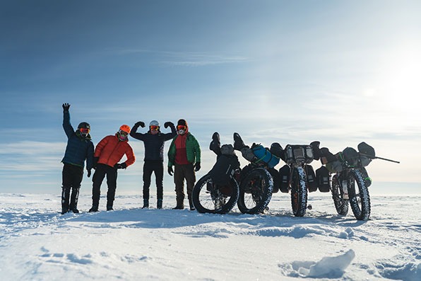
Our last day, we knocked out 49 miles in 3 hours 18 minutes. Eric rolled out early to snap some footage and take some pictures. Ryan, Ted and I rolled through, turn after turn. Not caring at all about sweating, we just enjoyed tapping out a steady rhythm in a tropical -4F. With about 10 miles to go, a near death pass by a snow plow with its blade down shook us up pretty good. The driver didn’t know his blade was lowered and was very apologetic. But having been over 300 miles in the far north with hardly any traffic to bother us, it was a sober reminder that we’re near the end of our ride and not fully connected to the busy highways. We rolled into Smooth Rock Falls to a greeting by the Mayor and First Lady, the town staff, and a great reception with food and even a hotel was offered. After 10 days, the James Bay Descent is done. 397 miles, $7,783 raised for charity and a few firsts under our belt. Thanks to all who followed along.